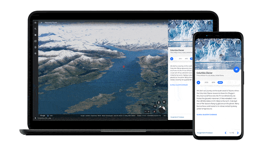
Google Earth Debuts New Timelapse Feature With a Timelapse Showing the Planet’s Changes Since 1984
Google, in partnership with the CREATE Lab at Carnegie Mellon University, has debuted its biggest update to Google Earth in years, featuring a timelapse that shows how much the planet and the climate have changed over the 37 years between 1984 and 2021.
We worked with experts at Carnegie Mellon University’s CREATE Lab to create the technology behind Timelapse, and we worked with them again to make sense of what we were seeing. As we looked at what was happening, five themes emerged: forest change, urban growth, warming temperatures, sources of energy, and our world’s fragile beauty. Google Earth takes you on a guided tour of each topic to better understand them.
This new timelapse feature uses over 24 million satellite photos that have been compiled in such a way to call up an interactive 4D experience on-demand.
We invite anyone to take Timelapse into their own hands and share it with others — whether you’re marveling at changing coastlines, following the growth of megacities, or tracking deforestation. Timelapse in Google Earth is about zooming out to assess the health and well-being of our only home, and is a tool that can educate and inspire action.
We’re unveiling a new dimension to Google Earth — time. Launched today with @nasaEarth @EU_Commission @USGS @esa, Timelapse in Google Earth provides a better understanding of Earth’s dynamic changes. Explore our changing planet: https://t.co/xz95CfPlaN pic.twitter.com/qsqWHsZ2at
— Google Earth (@googleearth) April 15, 2021