Skip to content
No results
  • About
  • FAQ
  • Hosting
  • Newsletter
  • Socials
  • Support
  • Contact
Laughing Squid
  • About
  • FAQ
  • Hosting
  • Newsletter
  • Socials
  • Support
  • Contact
No results
Laughing Squid

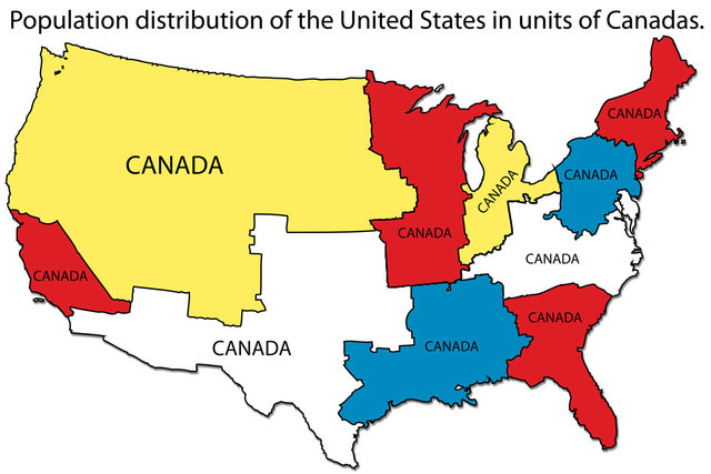
Map of the Population Distribution of the United States Measured in Canadas

  • Kimber StreamsKimber Streams
  • January 10, 2014

Population Density of the US Measured in Canadas
(larger)

This map created by Refah Seyed Mahmoud shows the population distribution of the United States as measured in units of Canadas. The entire population of Canada could fit into each outlined area on the map labeled “Canada,” which shows the higher population density in areas in the Northeast and Southern California.

via I Love Charts

Related Posts

Kimber Streams
Kimber Streams


  • Facebook
  • Bluesky
  • Threads
  • Mastodon
Check out our Managed WordPress Hosting
Laughing Squid Hosting

Trending on Laughing Squid

  • A Lively Split-Screen Cover of 'I Get Around' by The Beach Boys
    A Lively Split-Screen Cover of 'I Get Around' by The Beach Boys
  • Why Ships and Planes Measure Speed in Knots Instead of Miles or Kilometers per Hour
    Why Ships and Planes Measure Speed in Knots Instead of Miles or Kilometers per Hour
  • Cheerless Rehomed Cockatoo Finds Joy With a Dedicated Human Who Reads and Sings to Him
    Cheerless Rehomed Cockatoo Finds Joy With a Dedicated Human Who Reads and Sings to Him
  • Why Office Chairs Have Five Legs Instead of Four
    Why Office Chairs Have Five Legs Instead of Four
  • A Chilling Look at How Urban Dwellers in 1978 Might Survive Without Modern Technology
    A Chilling Look at How Urban Dwellers in 1978 Might Survive Without Modern Technology
Our blog posts may contain affiliate links. If you make a purchase through our site, we may earn a small commission.

Privacy Policy | Terms of Service
Accessibility Statement | Affiliate Disclosure

Powered by Laughing Squid Hosting and WordPress VIP
© 1995-2026 Laughing Squid LLC, all rights reserved