guest post by Jackson West
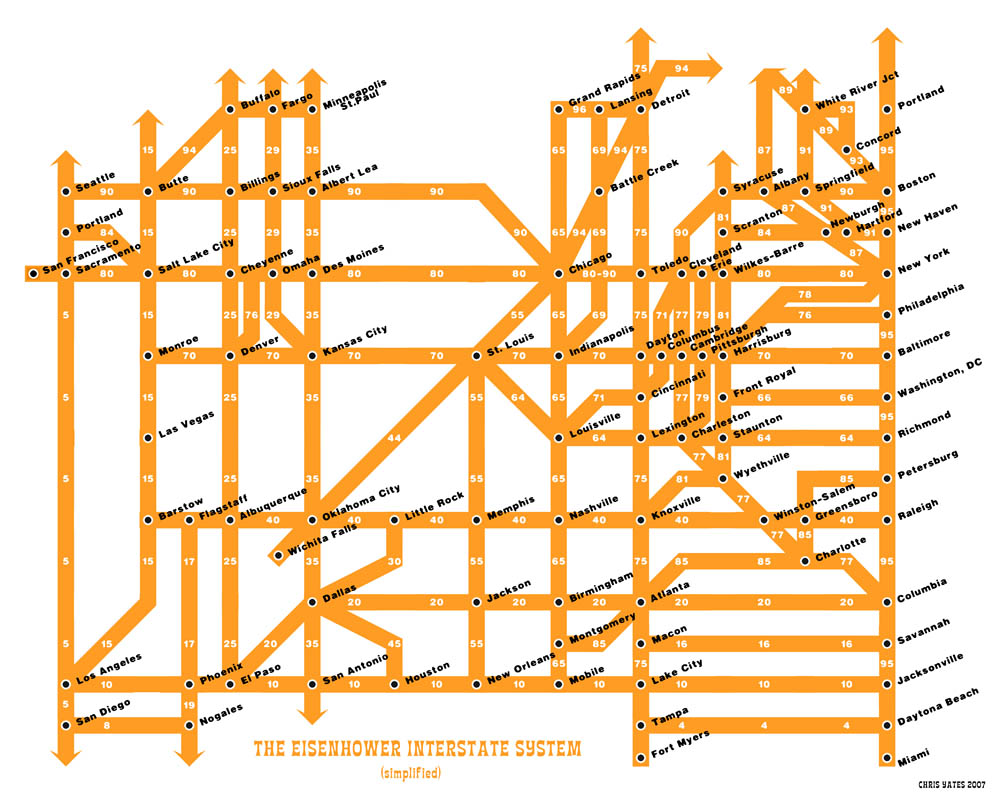
Boulder, CO artist Chris Yates created an abstract, London Tube-style map of Dwight Eisenhower’s Interstate highway system which you can buy as a print for $12 plus shipping. You know, in case you’re planning to defend the United States from a full scale ground invasion and need to move tanks from Butte to Buffalo as Eisenhower was. Otherwise, it brings to mind history, geography and transportation into one thought-provoking image.
Via Mark Schoenveld of The Poverty Jet Set, who also included another fascinating and beautifully designed illustration showing estimates of when worldwide mineral resources will be exhausted by industrial production. According to that graphic, key components in the cars that travel the aforementioned byways, including silver, aluminum, chrome and platinum may run out before even world oil reserves.
I don’t think Ike ever imagined building the world’s largest, national, paved bike trail network, but according to these maps that seems to be where this road trip is headed.
Here Are A Few Related Posts You Might Enjoy:
- Magic Highway USA, Disney’s Animated Future of Transportation
- The Art of Bleeding – Halloween Highway


{ 4 comments… read them below or add one }
Is this supposed to be the whole thing? Or just as it was originally planned? Because he basically left wisconsin off the map. Interstate 94 connects Chicago, Milwaukee, and Minneapolis/St. Paul, and is most certainly a non-trivial piece of the interstate highway system, which seems like it shouldn’t be left off the map. Interstate 39 and 43, however, I can accept.
Wow! Hey Jackson! Thanks for the shout. Yeah, pretty radical map. Thanks for tracking down the original artist – I tried. Updating my post right away.
Hey dudes, glad you like my map.
Justin, if you take a look at the extensive comments on my original post of the diagram, you can find out all the various “inaccuracies and omissions” contained in the map:
http://www.chrisyates.net/reprographics/index.php?page=424
This was designed back in 2000, as a graphic design project – I never intended it to be used for actual navigation.
There have also been several folks who have “revised” my map to attempt to make in more accurate like this one:
http://gochisanfrid.wordpress.com/2007/02/16/interstate-highway-system-map/
according to the wiki, i75 hangs a left at naples and goes to miami. http://en.wikipedia.org/wiki/Alligator_Alley