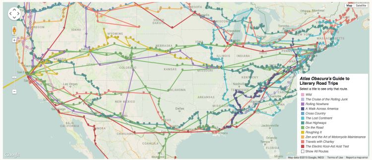
Writers Richard Kreitner and Steven Melendez of Atlas Obscura have compiled an amazingly detailed interactive map. The pair used Google Maps to painstakingly plot the different routes of twelve epic road trips taken by adventurous characters in American literature.
The above map is the result of a painstaking and admittedly quixotic effort to catalog the country as it has been described in the American road-tripping literature. It includes every place-name reference in 12 books about cross-country travel, from Mark Twain’s Roughing It (1872) to Cheryl Strayed’s Wild (2012), and maps the authors’ routes on top of one another. …To be included, a book needed to have a narrative arc matching the chronological and geographical arc of the trip it chronicles. It needed to be non-fictional, or, as in the case of On the Road, at least told in the first-person. To anticipate a few objections: Lolita’s road-trip passages are scattered and defiant of cartographical order; The Grapes of Wrath’s are brief compared to the sections about poverty and persecution in California; the length of the trip in Fear and Loathing in Las Vegas is short in the geographical sense even if it is prodigiously vast in every other; and yes, The Dharma Bums is On the Road’s equal in every respect, and if you want to map the place-name references in all of Kerouac’s books, I salute you.
image via Atlas Obscura